Download ArcGIS Desktop Entry 10.5.EADE105.PracticeTest.2019-10-17.36q.vcex
| Vendor: | Esri |
| Exam Code: | EADE105 |
| Exam Name: | ArcGIS Desktop Entry 10.5 |
| Date: | Oct 17, 2019 |
| File Size: | 603 KB |
How to open VCEX files?
Files with VCEX extension can be opened by ProfExam Simulator.
Discount: 20%
Demo Questions
Question 1
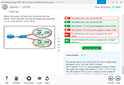
Refer to the exhibit.

The exhibit below provides a conceptual view of a coordinate grid onto which all coordinate values snap to the grid mesh. The grid covers the extent of each dataset. An ArcGIS user is creating a new feature class, and needs to increase the numeric precision used to store the coordinate values.
When modified, which of the following will increase the numeric precision used to store the coordinate values?
- X,Y Tolerance
- Z value
- M Value
- X,Y Resolution
Correct answer: D
Explanation:
Reference: http://webhelp.esri.com/arcgisdesktop/9.2/index.cfm?TopicName=Feature_class_basics Reference: http://webhelp.esri.com/arcgisdesktop/9.2/index.cfm?TopicName=Feature_class_basics
Question 2
A biologist must go into the field and record locations of every site that currently has standing water with mosquito larvae.
Which application should the biologist use?
- ArcGIS Online
- ArcGIS Pro
- Navigator for ArcGIS
- Collector for ArcGIS
Correct answer: D
Explanation:
Reference: https://doc.arcgis.com/en/collector-classic/android/create-maps/track-where-collectors-went.htm Reference: https://doc.arcgis.com/en/collector-classic/android/create-maps/track-where-collectors-went.htm
Question 3
A GIS user has an address and must display the location of the address as a point on the map. The user has a general idea of where the address is located but needs a precise result
How should the user efficiently perform this task in ArcMap?
- Type the full address in the search field of the Geocoding Toolbar, and press Enter
- Zoom in to the city, pan to the street. and use the Address Inspector on the Geocoding Toolbar
- Open the Go To XY tool and search the full address
- Open the Geocode Addresses tool from the Geocoding Toolbar and search the full address
Correct answer: C
Question 4
A GIS analyst is editing several feature classes associated with city utilities. The analyst selects a line feature class that represents the city's gas main, and opens Create Features.
By default, which type of features are created?
- Points
- Multipatch
- Polygons
- Polylines
Correct answer: D
Explanation:
Reference: http://desktop.arcgis.com/en/arcmap/10.3/manage-data/geodatabases/feature-class-basics.htm Reference: http://desktop.arcgis.com/en/arcmap/10.3/manage-data/geodatabases/feature-class-basics.htm
Question 5
An ArcMap user needs to inspect the geometry and attribute schema properties of a file geodatabase feature class. The user does NOT want to add the feature class to a map.
How should the user perform this task using the Catalog window?
- Add or use a folder connection to the file geodatabase > Open the Item Description context menu of the data
- Add or use a folder connection to the file geodatabase > Open the Properties context menu of the data
- Navigate to the Conversion Tools > Export Metadata Toolset geoprocessing tool
- Add or use a folder connection to the file geodatabase > Open the Properties context menu of the geodatabase
Correct answer: C
Explanation:
Question 6
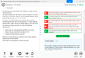
Refer to the exhibit.

What does the text in the box describe?
- One inch equals 1567 feet
- One inch equals 1567 units
- One unit equals 1567 feet
- One unit equals 1567 units
Correct answer: A
Explanation:
Reference: http://desktop.arcgis.com/en/arcmap/10.3/map/working-with-arcmap/working-with-map-scales.htm Reference: http://desktop.arcgis.com/en/arcmap/10.3/map/working-with-arcmap/working-with-map-scales.htm
Question 7
A GIS analyst is working with a large number of polygon features in a layer in ArcGIS Pro and needs to display only a subset of features but retain all records in the attribute table.
How should the analyst accomplish this task?
- Apply a display filter on the polygon layer to exclude certain features based on a SQL expression.
- Apply a definition query on the polygon layer to exclude certain features based on a SQL expression.
- Apply a page query on the polygon layer to exclude certain features based on a SQL expression.
- Apply a display filter on the polygon layer to exclude certain features based on a SQL expression.
Correct answer: B
Question 8
A landscape designer needs to create features that represent landscaping plans. The employee opens a new project, adds a map, and opens the Create Features pane. The employee receives an error in the pane.
Which step did the employee miss during the editing workflow?
- Enable editing on the map
- Add an editable layer to the map
- Enable Feature Analysis on the Portal
- Press the Status button under Manage Edits
Correct answer: B
Explanation:
Question 9
Which data format can be added as an item to ArcGIS Online?
- File geodatabase in a folder
- Shapefile in a zipped folder
- XML workspace document
- Geometric network
Correct answer: B
Explanation:
Reference: https://doc.arcgis.com/en/arcgis-online/manage-data/add-items.htm Reference: https://doc.arcgis.com/en/arcgis-online/manage-data/add-items.htm
Question 10
A GIS analyst receives a file geodatabase containing various feature classes. The analyst must find additional information regarding the author, credits, and use limitations on many of these feature classes.
How should the analyst find these details?
- Bring each feature class into a map document > Open the attribute table
- Bring each feature class into a map document > Look at the layer properties
- Right-click each feature class in the Catalog window > Item Description
- Right-click each feature class in the Catalog window > Properties
Correct answer: C
HOW TO OPEN VCE FILES
Use VCE Exam Simulator to open VCE files
HOW TO OPEN VCEX AND EXAM FILES
Use ProfExam Simulator to open VCEX and EXAM files
ProfExam at a 20% markdown
You have the opportunity to purchase ProfExam at a 20% reduced price
Get Now!